
The Disintegration of Roman Britain:
With the removal of Rome’s military support by around 411 the centralised adminisration of occupied Britain disintegrated, although the form and values of Roman life were not instantly overthrown. It was still hoped that Britain would become a Roman province again and an appeal for military aid was made to a Roman army campaigning in Gaul as late as 446. Once the Roman legions had withdrawn and imperial power within the British Isles had evaporated in the early fifth century, an older political pattern reasserted itself. Both in Britain and in Ireland the fundamental units of authority were the petty kingdoms, based upon the force of warrior bands sustained by booty and tribute. The Christian Church became a part of these societies only gradually. Already well-established in Roman Britain, Christianity in Cambria (or ‘Waleas’, ‘land of foreigners’ as the Anglo-Saxons called it), Cornwall (West Wales) and Cumbria, areas where the there was no sharp break with the Roman past. In Ireland, Strathclyde, and other kingdoms and territories north of Hadrian’s Wall, areas which were not continuously part of the Roman Empire, ‘Celtic’ missionaries introduced Christianity in the fifth, sixth and early seventh centuries, and went on to spread the faith among the Northumbrians and the Angles who had settled along the North Sea coasts during the fifth and sixth centuries. But from the time of their arrival until the beginning of the seventh century, the Angles, Saxons and Jutes remained largely impervious to Christianity. They remained true to their gods, Woden and the other deities in the Northern pantheon. The Romano-British Church was more interested in converting the remaining Celtic pagans on a line stretching from Dorset up to Strathclyde. Although a Roman mission under Augustine converted the Jutish kingdom of Kent in 597, it took a further generation for it to become properly established, and a further century for the whole of the British Isles to become part of ‘Christendom’.
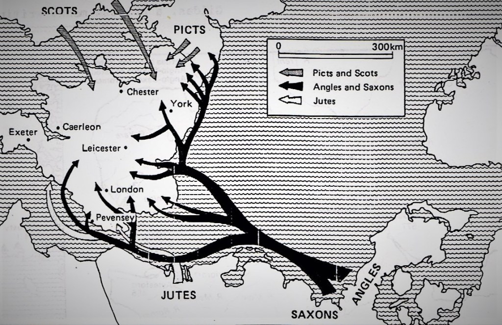
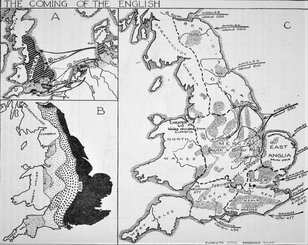
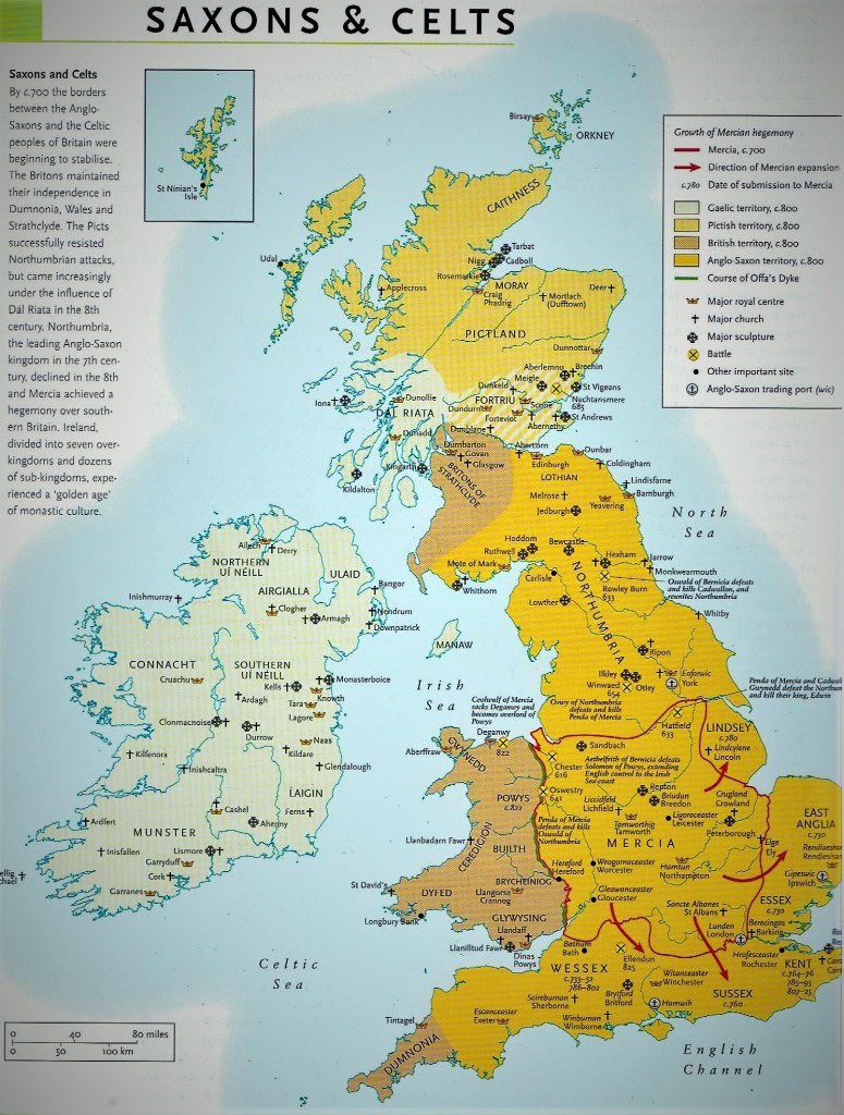
The collapse of the Roman province of Britannia created a vortex that drew Germanic migrants from across the Channel and propelled native peoples around the British Isles. Although in many respects the social and political consequences of that two hundred year period of immigration were felt most strongly in southern and eastern Britain, where Roman culture had become most entrenched, the upheaval affected all parts of the islands. The coming of the Angles, Saxons, and Jutes is the most important event in the history of those islands. But we have only a vague idea of what actually happened during the two hundred years of the incursions and settlements. The Saxons themselves left no contemporary written records, though their burial-places have provided rich sources of archaeological evidence. Britain was at first raided and then settled by the Saxons from North Germany, from the land between the rivers Ems and Elbe; by the Angles from what is now Southern Denmark; and by a smaller group, the Jutes, who came from Frisia, on the shores the Zuider Zee. The map above shows that the Jutes attacked Kent and the Isle of Wight, that the Saxons went to Southern England, and the Angles went to land further north in what became known as East Anglia, Mercia and Northumbria. The attacks were first made by small bands of warriors, at different parts of the coasts and at different times. There was no co-ordinated full-scale invasion. Possibly uniting for a time under a single leader, they moved speedily up the rivers in their long-boats, storming and destroying Roman towns and killing remaining inhabitants. Many Britons had already fled westward. After they had completed their work of destruction, the raiders turned back to settle and cultivate the lands they had ravaged. The map below illustrates the progress made in the settlement of the country between the fifth and seventh centuries.
Anglo-Saxon Incursions, Migration and Settlement:
The arrival of the Anglo-Saxons coincided with a drastic decline in towns and a reorganisation of the landscape, partly as a result of large-scale population movement. London was probably the only place where some semblance of urban life continued, and even there the centre shifted to the west, to an area outside the Roman walls. Elsewhere, towns were largely abandoned, some never to be reoccupied, others, like Winchester and Canterbury, eventually to be reborn as royal centres. A handful of new trading points were established, as at Hamwith (Southampton) and Ipswich. In the North and the West some Roman fortresses became local political centres, notably at York and Carlisle, but most were ignored. The arrival of the ‘Anglo-Saxons’ as they became known by later historians, initiated a period of struggle and decline, which saw the mass migration both across the North Sea and the Irish Sea, as well as the creation of a new political order out of the warfare and chaos which was endemic in post-Roman Britain.

From the perspective of the Celtic- and Brythonic-speaking peoples, this provided the context for the heroic, though largely legendary, efforts of ‘King Arthur’ or ‘Artorius’ in resisting the Anglo-Saxon expansion into western Britain. From this period of incursion and settlement, traditionally referred to as ‘the Dark Ages’, emerged a pattern of of ethnic, cultural and linguistic development which calls into question this epithet. Nonetheless, it does hold a substantial element of truth when applied to the sources available to the historian. Written evidence in the form of manuscripts such as the Anglo-Saxon Chronicle, the De Exidio de Conquestu Britanniae of the monk Gildas, Bede’s Ecclesiastical History of the English Nation and the tenth-century compilation of known as Nennius’ History of the Britons, allow the outline of events to be constructed, but the interpretation placed upon them by these sources is at best ambiguous, and at worst totally misleading.

Fortuitously, additional sources in the form of charters and statutes, archaeological evidence and the study of place names, can be used to qualify and amplify the narrative. The major themes that emerge are the transition of the ‘English’ peoples from groupings of small kingdoms into a single monarchy; the assimilation of the Anglo-Saxons, and the conversion of the English to Christianity. The outcome of battle was fundamental to the development of the first two, and war, on occasion, was the precursor to the advance of Christianity over paganism. We will never know the full extent of the fighting between Briton and Anglo-Saxon but The Anglo-Saxon Chronicle does throw some light on the nature of warfare at the time. The desire to annexe and settle enemy territory was one of the prime reasons for war, but there were other motives. Battles could result from feuding between rival claimants to the throne, from the harbouring of domestic exiles, from the attacks of marauding war-bands, and from raids aimed at seizing livestock, especially valuable cattle. Warfare took a number of different forms, including attempts to repel seaborne landings, and to capture strongholds such as Roman fortifications or pre-Roman hill-forts and river crossings. River lines formed a natural defensive position and battles often centred on fords or other crossing points.

The Roman legions had come to Britain as professional soldiers under orders to conquer an island whose possession might further the interests of Rome. But long before they left, a new force had appeared on the scene. They had first appeared in the Channel as early as the second century. The Angles, Saxons and Jutes came as peoples hungry for land and loot. Finding that Britain could satisfy their desires, settlement and eventually folk-migration followed. The initial incursions were resisted by the native Britons, but their dynasties and armies were gradually pushed westwards over the course of the two centuries that followed. The Anglo-Saxons, as the different tribes became collectively known, were great fighters and seafarers and, when they settled, skilful farmers. The Romans had held a healthy respect for them and even admired them, having first encountered them on the northern borders of their continental empire, but they had also created a special command to deal with their marauding ways around the eastern coastline of Britain. This had come under the ‘Count of the Saxon Shore’ who had a chain of forts and a fleet of warships to help in the task of defending the island from attack across the North Sea. The Romans have traditionally seen as land-based people, moving their armies swiftly along their magnificent straight roads to confront their enemies in set-piece battles. In fact, they were extremely flexible in their military strategies, and adaptable in their use of seaforts and navies to keep the ‘sea-wolves’ at bay. The Romans had done everything they could to integrate themselves into British life over their four centuries of occupation, but the fact that they were still seen by many natives as occupiers is perhaps borne out by their failure to train and equip the Britons to defend themselves against external attacks.
The Defence of Britannia’s Shores:
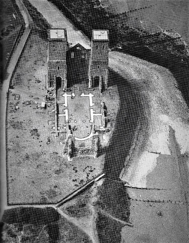
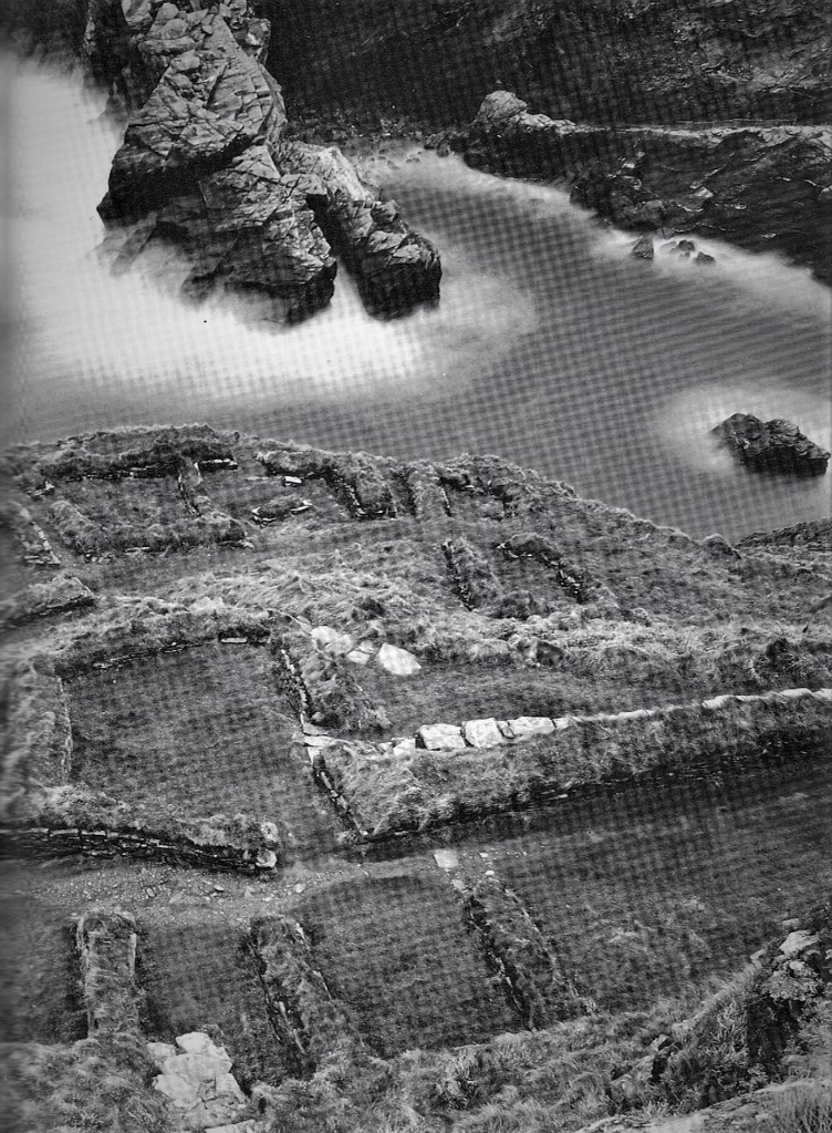
By the 7th century Reculver had become a landed estate of the Anglo-Saxon kings of Kent. The site of the Roman fort was given over for the establishment of a monastery dedicated to St Mary in 669 AD.
It is perhaps not entirely fair, therefore, to blame the subsequent successful incursions by the Angles, Jutes and Saxons on the lack of military experience and preparadeness of the Britons themselves. Many Britons had served with some distinction in the Roman legions, as I detailed in my previous article, and had fought their way across Gaul as far as the western imperial capital itself. They were as skilled and brave as their fellows in arms from anywhere else in the empire. The tales of Macsen Wledig in the Welsh Mabinogion are testimony to this. But the Britons did not seem to appreciate early or widely enough the new form of coastal warfare that they needed to employ against the incursions which followed Rome’s withdrawal. For one thing, the seaforts built by the Romans needed contant reinforcement and garrisoning against forces that were more numerous and more experienced in this form of warfare. But on at least one occasion the Britons did use exactly the right tactics against their opponents, and that was at Mount Badon. The Jutes had arrived first, by invitation, and were the first to settle and establish themselves in Kent. Having quarrelled with and driven out their hosts, they demanded a large slice of the south-east. There were still Romans in Britain at that stage, but they were without any military power. In the Anglo-Saxon Chronicle for 443, we read:
In this year the Britons sent across the sea to Rome and begged for help against the Picts, but they got none there, for the Romans were engaged in a campaign against Attila, King of the Huns. And then they sent to the Angles, … and made the same request of the chieftains of the English.
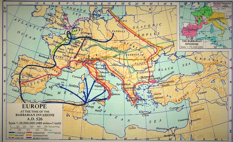
At this time the Vandals marched through Gaul and into Spain, plundering as they went (see the map below). After crossing the strait of Gibraltar, they easily took control of North Africa before re-crossing the Mediterranean to attack Rome in 455. Meanwhile the Huns, continuing their destructive march, had also entered the Roman Empire. Led by Attila, they ravaged the land as far as Constantinople. They then moved westward towards Gaul where at Chalons, near Troyes, in 451, the Visigoths and Romans united to oppose them. Attila turned back towards Italy, but the Pope persuaded him to withdraw across the Danube. The next year Attila died and the Huns fell into disorganised groups, ceasing to be a threat to the Empire. However, the Barbarian invasions of the Empire continued into the sixth century, most notably by the Franks, as shown on the map above, at the same time as the incursions into Britannia continued unabated. The Emperor Justinian (527-565) attempted to recover the provinces lost to the barbarians, and his general had some success in this in Africa, Spain and Italy. But these provinces were soon easily lost again, to the Moors and the Lombards, because they were too far away from Constantinople.
Unfortunately for the Britons, they soon discovered that their hoped-for saviours proved to be the next aggressors themselves. Two military strategies appear to have been put forward to deal with the barbarian threat after the break with Rome. Each policy was supported by rival adherents whose partisanship developed into mutual hostility and war. The rival leaders may have been Vortigern and Ambrosius Arelianus; it appears that the former, whom Gildas describes as superbus tyrannus, was the principal military leader of the Britons in the fifth century. The name ‘Vortigern’ can be translated as ‘high king’ although the exact status of this figure remains uncertain. What is widely accepted is that he was responsible for bringing Saxon mercenaries to Britain to provide a defence against attack by Picts and Scots. It is possible, however, that the real significance of this strategem was to repel a Roman landing from Gaul in support of Ambrosius. Thus Vortigern’s decision to base the mercenaries along the North Sea Coast and to surrender Kent as an area for further settlement can be explained by the need to create a ‘buffer zone’ against an attack from across the Channel.
Vortigern’s employment of barbarian allies was by no means original and it is probable that Germanic settlers co-operated in the defence of forts and towns even before the Romans withdrew. Whatever the precedents, Vortigern’s policy was a catastrophe for the Britons. The mercenaries comprised Angles, Saxons and Jutes and it seems certain that their role as allies started earlier and developed more gradually than is suggested by Bede’s later account of a single mass descent led by Hengest and Horsa around 450. At first the visits of the Saxon warriors were no real threat, as they accepted land and money in return for their military service, but as reinforcements arrived from their homelands across the North Sea and their strength increased they were encouraged to rebel by the apparent weakness of their hosts. Consolidating their hold on the eastern coastal areas, they launched savage raids to the north and the west. Vortigern’s allies turned on him and swarmed all over southern and eastern Britain, carving out independent estates and kingdoms for themselves. Hengist and Horsa fought Vortigern at a site called Aegelsthrep where Horsa was killed, and then Hengist and his son Aese won a decisive victory against the Britons at Creacanford, a site which cannot easily be identified. Now the floodgates were opened and a succession of warlords crossed the North Sea in their long shallow-draught boats to probe the coast, rivers and inlets of East Anglia in search of land which was vacant or could easily be made vacant.
Who were the Invaders?
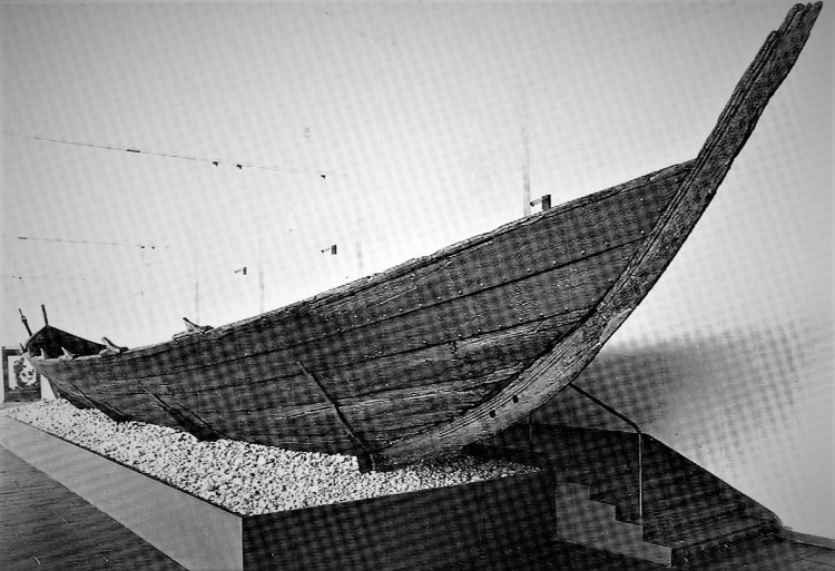
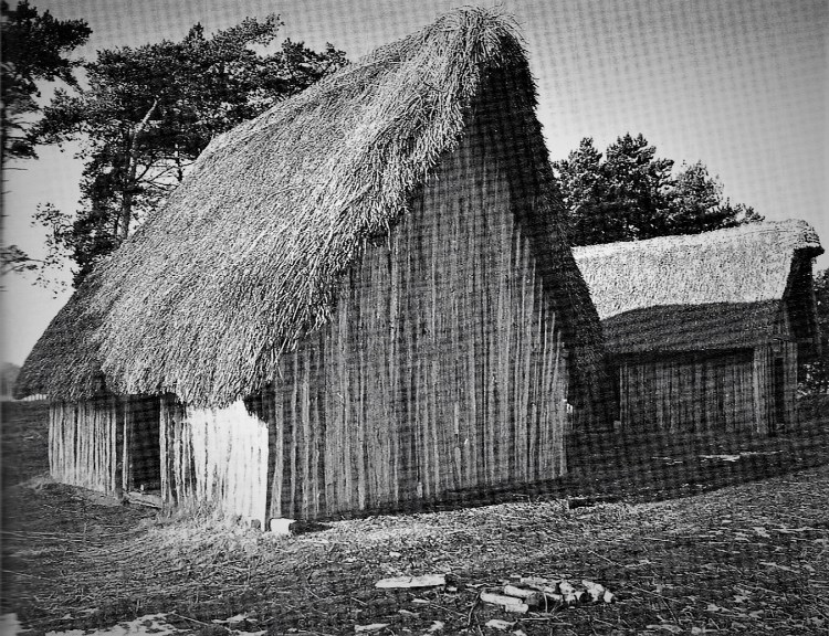
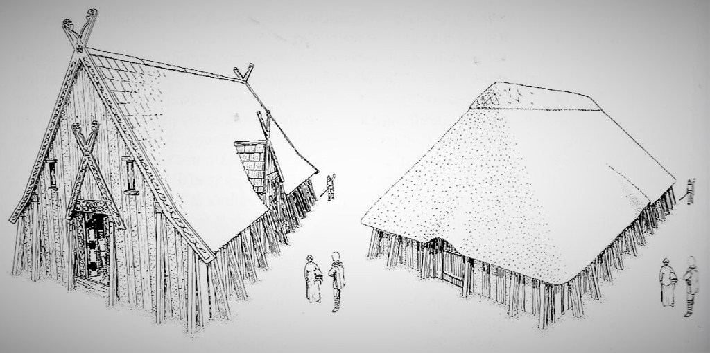
Who were these Anglo-Saxons from whom the greater part of our present population is descended? They were fishermen-farmers from Schleswig-Holstein, North Germany, the North Frisian Islands and, perhaps, from Denmark. Pottery finds suggest that we are here dealing with quite a large number of distinct communities who came severally and over a long period of years in their seventy-foot-long, oar-propelled boats. This was no concerted invasion, but a piecemeal settlement similar to that of the Celts which had taken place over the millenia ‘before the Romans came from Rye’. They rowed up the rivers, first advancing from the Wash and penetrating the Breckland. Later raiders pushed up the Deben, the Gripping and the Orwell to establish settlements on the Sandlings. The new culture established itself rapidly and completely. All Latin traces quickly vanished as Romano-British landowners fled westwards or established a modus vivendi with the strangers. The peasantry found it easier simply to adopt the language and customs of their new masters. Old names were soon lost without trace, and new ones appeared, like Gipeswic (‘the settlement by the estuary’ – Ipswich), Sudbyrig (‘the southern fort’ – Sudbury). ‘Ham’,’Wic’, ‘Tun’, ‘Weorde’ are all words, suffixes which indicated small settlements, fortified homesteads where single families lived with their servants. Notably, the newcomers had no word for town since the concept of urban life and the complex social interrelationships it implied was alien to them. The Saxons, like most Britons, lived in small self-sufficient units, in round houses of timber and thatch within stockades which provided shelter for man and beast. The communal fire was the centre of every homestead, while the ‘thegns’ lived in more imposing timber halls where they feasted their warriors, discussed forthcoming campaigns and listened to songs and sagas of ancient valour.
Vortigern disappears from the historical record by 460 and thereafter British resistance to attacks centred on the leadership of two men with Latin names, Ambrosius Aurelianus and Artorius (Arthur). In 477, the formidable Aelle arrived with his three sons and killed many Britons and drove some into flight. Aelle was clearly a warrior king whose principal pastime was making himself an intolerable nuisance to his neighbours both in his homeland and across the North Sea. He found Britain a tempting target with people to be plundered and occupied. One of the his sons, Wlencing, gave his name to Lancing near Shoreham, and another, Cissa, to Chichester. The Britons made the fatal mistake of trying to hold him off from fixed defences with no sally-ports, resulting in them becoming besieged in old Roman forts, as at Pevensey. Aelle and Cissa captured the fort and killed every man, woman and child within its walls. After this massacre, Aelle founded the Kingdom of the South Saxons, later becoming the County of Sussex. From its founding, the Saxons arrived in increasing numbers. Some landed further west, and founded the Kingdom of the West Saxons or Wessex; others founded the Kingdom of the East Saxons, the County of Essex. Angles, Saxons and Jutes all came from contiguous areas on the continent, and it is surprising that the early chroniclers were expert enough to be able to distinguish between them. All were formidable in war, but none more than the Saxons whose achievements were only too well known on the Continent. One of sources is the sixth-century monk, Gildas, who described their effect on Britain:
… famine dire and most famous sticks to the wandering and staggering people, priests and … swords on every side gleaming and flames crackling were together mown to the ground … fragments of bodies covered with clots as if congealing of purple-coloured blood, mixed in a sort of fearful winepress, and burial of any kind was there none except the ruins of houses, the bellies of beasts and birds in the open …
Archaeology has begun to shed some light on the ‘Dark Ages’, where documentary evidence is lacking. The distribution of pagan fifth-century Anglo-Saxon burials indicates the probable areas of earliest Anglo-Saxon settlement in Britain. As the map above shows, the ‘English’ advance continued throughout the period – though both English and British kingdoms fought as often among themselves as against each other. Inscriptions in the Irish ogham alphabet, also adopted by the Picts, point to each area of Irish settlement in the southwest, west Wales and soutwest Scotland; Latin memorial stones reflect successful British campaigns to drive the Irish out. Meanwhile, British and then Irish missionaries spread Christianity throughout Ireland and Picts; by the end of the period Irish, continental and native British missionaries had also begun the conversion of the Anglo-Saxons.
At first the Britons could do little except flee or stand and be slaughtered. Many chose to take their chances in the woods, for there was no safe haven in the towns the Romans had left. The Saxons did not occupy the buildings they had not destroyed; this concept of the civilised life was beyond their grasp, but they did make use of the Roman roads to penetrate deep and wide into Britain. Out of their misery the Britons had to develop a new form of life and warfare. Like their ancestors of some five hundred years before they began to display the skills of guerilla fighting which had impressed the first Roman invaders. We know from Roman accounts that the Britons were highly mobile, could race around in chariots, alight, fight and leap back on to their horses and chariots. But these skills had long been forgotten, and were never completely revived. Instead the Britons evolved a more cautious form of warfare, with a technique of ambush. They were slow, however, to learn the strategy of avoiding pitched battle, as we can read in the Anglo-Saxon Chronicle:
495: In this year two chieftains, Cerdic and his son Cynric came with five ships to Britain at the place which is called Cerdicesora, and they fought against the Britons on the same day.
501: In this year Port and his two sons Bieda and Maegla came to Britain with two ships at the place … called Portsmouth and there they killed a young British man of very high rank.
508: In this year Cerdic and Cynric killed a British king whose name was Natanleod and five thousand men with him, and the land right up to Charford was called Netley after him.
514: in this year the West Saxons came with three ships at a place which is called Cerdicesora and Scuf and Wihtgah fought against the Britons and put them to flight.
These early battles or skirmishes were strenuous and bloody enough to impress the chroniclers but they were not decisive. The Saxon raiders would celebrate their victories with plunder and senseless destruction but at this stage they had few constructive ideas as to how to consolidate their gains. Had they been well led, the Britons could have ambushed these marauders on their return to the coasts and recaptured most of the spoils. But apart from certain isolated occasions, they seldom did so. The Saxons either set sail for their homeland or settled near the coast in this new territory. Many of the Britons had fled far beyond the farthest point of Saxon penetration, deep though that was in places, in order to gain the protection of the ancient hillforts. The Saxons referred to all the Britons as the ‘Waelisch’, which meant ‘foreigners’ or, perhaps more precisely, ‘outlanders’, which gave the name to the territories where some of the Britons settled and survived, and eventually to the nation which emerged from the Dark Age principalities and kingdoms of Powys, Gwynedd and Dyfed. Gildas’ account of the misfortunes of these ‘refugee’ Britons was substantiated by Bede, who wrote:
Consequently some of the miserable remnants, being taken in the mountains, were slain in heaps. Others, constrained by hunger coming forward, yielded hands to their foes to undergo for the sake of food perpetual slavery, if indeed they were not immediately killed. Others, sorrowing, sought countries over sea. Others, remaining in the fatherland, led a wretched life in mountains, woods, and steep crags, always with apprehensive mind.
Artorius, The Battle of Badon & The British Resistance:
But both Gildas and Bede were glossing their chronicles with their own tales of woe and narratives of defeat and misery to the situation, which was never as bad as they made it seem, if we take into account other sources of evidence, which testify to the determination of the royal dynasties of the Britons to resist and even defeat the ‘seawolves’ from the security of their own heartlands in the West. They therefore reverted to being leaders of guerilla ‘warbands’. Apart from the abandoned Roman towns and roads, and the Britons’ own trackways and upland forts, most of Britain was still covered with forest, thickets, moorland and marsh. Little of the land had been drained or cleared in Roman times and by 516 more than a century had passed since more peaceful times, during which drainage system had been neglected and thickets had been allowed to grow back. The Britons had no shortage of inaccessible hideouts; their problem was to find the leaders to organise their resistance, train their scattered bands, and mount an effective series of counter-attacks. But the Britons had such leaders, first in Ambrosius Aurelianus and then Artorius, known in legend and literature as Arthur.
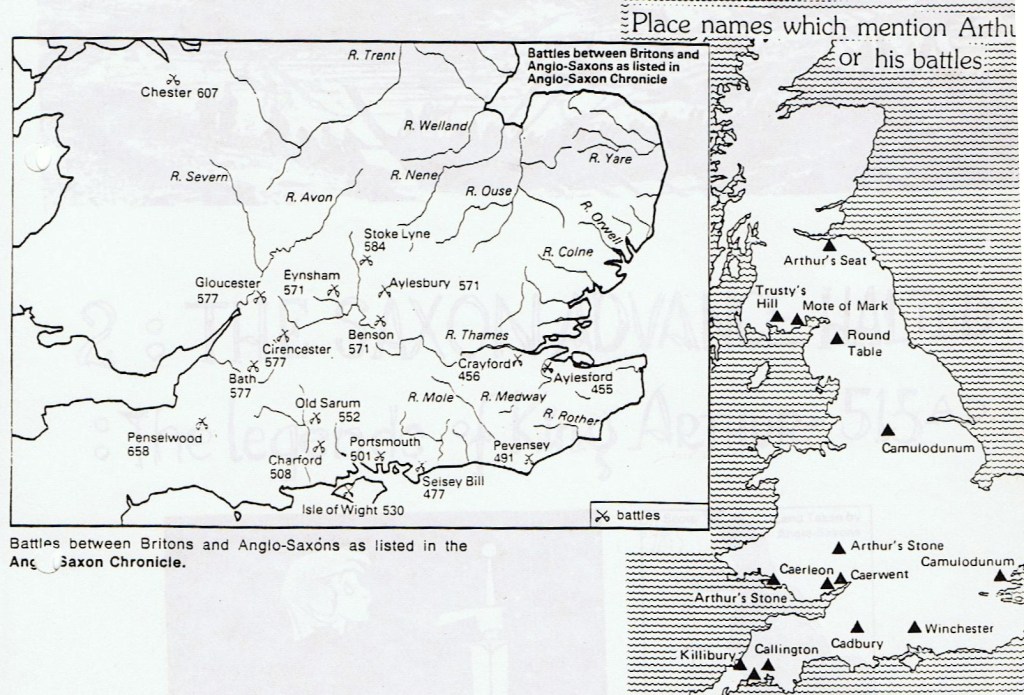
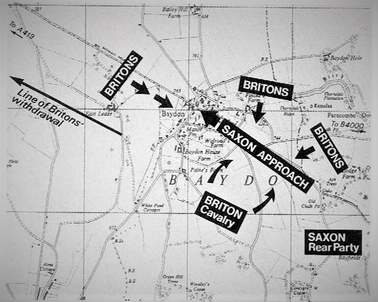
The truth is that the fortunes of war swung much more evenly between the Britons and the Anglo-Saxons after the initial coastal clashes and incursions, but after the loss of the fort at Pevensey in 477, Britons seem to have begun and ended a series of campaigns lasting nearly forty years with significant victories. The first was achieved under Ambrosius, but the concluding victory at Mount Badon was probably gained by a force under Artorius’s command. The Historia Brittonum lists twelve battles fought and won by Arthur of which only one, fought in the Caledonian Forest, can be identified to a particular site with any degree of confidence. Mont Badon, the last of the twelve, was probably fought at some point between 494 and 499, though some sources date it to 516, on a site in the south-west Midlands. Attempts to identify the precise site of the battle have centred, perhaps mistakenly, on the search for a suitable hill-fort. It has been suggested that the British name for the the site was ‘Din Badon’ meaning ‘Badon Fort’, and that the defeated Saxons translated this into ‘Baddanburg’ or ‘Badda’s Fort’, thereby implying a link with one of five modern Badburys between Dorset and Lincolnshire. Favoured sites have included Badbury Rings in Dorset and Badbury by Liddington Castle in Wiltshire. Archaeologists and military historians think that they have found the likely British stronghold at the latter, an Iron-Age fort on a nine-hundred-foot hill. It has a useful high bank and ditch, and on the hill slopes are traces of other works which made the path of the attacker hazardous. Here, it seems, the Saxons located the rest of the force which had inflicted such damage on them the previous day (see below). Perhaps there had been another brush at the crossroads and the Saxons had been led in pursuit to Liddington. Up till recent times Liddington was known as Badbury Castle, i.e. the ‘burgh’ at Bad(on). But, as noted below, we may not need to locate a hill-fort site. Welsh tradition identifies Badon with Bath and It is possible that the battle was fought on one of the hills surrounding the town.
The Battle of Mount Badon or Mons Badonicus has been somewhat of a mystery for over fifteen hundred years. Records are scanty and there has been much speculation over its exact site. It was an enormously important battle, and its result delayed the subjugation of Britain for at least fifty years. It was undoubtedly a masterpiece of strategic and tactical planning. Perhaps much of the mystery stems from the fact that Badon was chronicled by scholars and monks who were far away in both place and time, and who did not know the area in which it was reputedly fought. Today, the obscurity of Badon seems a little less impenetrable, at least from a military strategist’s point of view.
Quoted in Philip Warner’s (1976) book, Famous Battles of the Midlands, one such strategist, Col. Burne accepts most of Geoffrey of Monmouth’s twelfth century account of the battle while acknowledging that on some matters, Geoffrey’s versions of events, not least concerning ‘King Arthur’, were somewhat imaginative. There has been much discussion and debate as to who Arthur may have been, but there now seems to be a consensus among historians that (if he is one and the same as the historical Artorius) he was not a ‘king’ but rather a ‘warlord’, the military leader of the forces of a number of small British kingdoms. Whether this general of the Britons was Ambrosius Aurelianus or Artorius, or both, can never be established. One theory is that ‘Arthur’ was one of the names by which Ambrosius was known to his men. Ambrosius has been identified as a Romano-British aristocrat whose parents had been mudered by Saxon pirates. He had narrowly missed being killed himself, and decided to set up a resistance force. Guerilla leaders seldom use their own names, of course (we need only think of ‘Robin’ Hood or ‘Che’ Guevara). Gildas describes him in the following terms:
Ambrosius Aurelianus being leader, a modest man, who alone by chance of the Roman nation had survived in the collision of so great a storm, his parents doubtless clad in the purple, having been killed in the same, whose progeny now in our times having greatly degenerated from their ancestral excellence, to whom, the Lord assenting, victory fell.
Bede put it a little more coherently when he wrote later, based on Gildas:
But when the hostile army, having destroyed and dispersed the natives of the island returned home, the Britons by degrees to resume strength and spirit, emerging from their hiding places, wherein they had concealed themselves, and with one accord imploring celestial help lest they should be destroyed even to extermination. They had at that time for their leader Ambrosius Aurelianus, a modest man, … Under this leader therefore the Britons took heart, and challenging their victors to battle obtain the victory …
There is, according to Warner, no reason to believe that Arthur and Ambrosius were not different people, that the former had his headquarters in the West, perhaps at South Cadbury near Glastonbury and/or Tintagel in Cornwall (both pictured below), where he trained his forces and into which the Saxons were not able to penetrate, and that Ambrosius was was based in Gwynedd, where he became an expert in hill-fighting. But it was just possible that they were one and the same man, in keeping with elements of the folklore passed down through legend and literature. The Latin meaning of Ambrosius is ‘immortal’, and the name lives on in the Welsh name ‘Emrys’. Aurelianus means ‘golden’ and ‘Arthur’ is thought to derive from the Brythonic word for ‘bear’, a suitable nickname for a guerilla leader. Of the twelve battles supposedly fought by Arthur, seven were connected with rivers. It has been suggested that actions fought at river crossings gave the mounted Britons a natural superiority over Anglo-saxon infantry, but in fact the advantage of deploying cavalry probably lay in the speed and and mobility they offered in reaching the battlefield. Arthur’s horsemen were not the heavy cavalry suggested by the legendary tales of chivalric ‘knights’ and would not have been able to deliver effective shock action. They would not have ridden down opposing infantry with horse and lance but used the horse as a mobile platform from which to throw their spears before attacking with swords drawn. The emphasis of warfare still lay firmly with individual feats of arms rather than with the unity of action required in a disciplined cavalry charge.
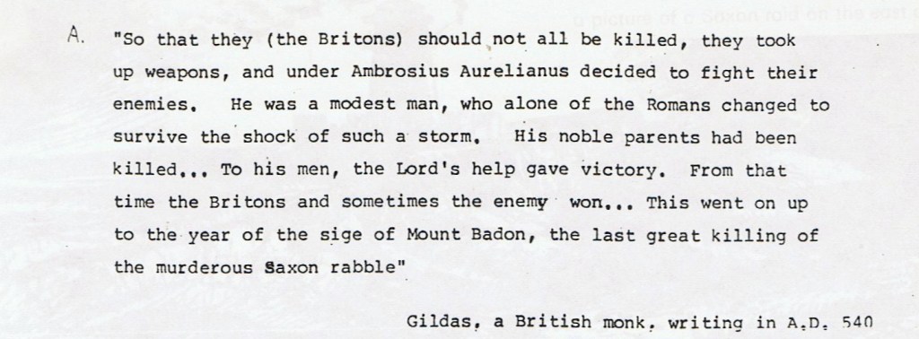
We see from the Anglo-Saxon Chronicle that the main Saxon raids were separated by several years. There would be a raid, a battle or two, and the return to the homeland or the shoreline, as referred to above. The early Saxon incursions had neither the administrative nor the necessary logistical support to mount a long campaign into areas of the hinterland where where the opposition was unknown and and food supplies would be precarious to say the least. But in 516, according to Gildas, a Saxon force of considerable strength was moving along the Ermine Way between Silchester and Swindon. Whether it was in 516 or twenty years ealier, as suggested above, makes little difference: It was a tough, resourceful fighting force which was moving north-west along the straight Roman road, but as the mile succeeded mile, with not a Briton in sight, it looked as if the Saxon warrior’s reputation had cleared the way before them. They saw no reason to use scouts or proceed cautiously. At the end of this stage, there was said to be another old Roman town, and after that the sea again. They were right. Swindon lay ahead, and after that the ‘Severn Sea’, known now as the Bristol Channel. But, unknown to them, Ambrosius and his Britons were marching in the same direction along the Severn and the Avon. As they approached Badon, or Bath, it looked no different from anywhere else along the route. They marched along the plateau, down the dip and up the slope into what is now Baydon village. When they were half-way up that slope, the trap was sprung. It is not difficult to reconstruct the probable sequence of events. Possibly two swift flank attacks took place from the cover close to the road, with another force directly in front including cavalry which would send the Saxons reeling back down the hill, and there was probably an attack around the rear over the route they had just covered; this would ensure that once they had tumbled to the bottom of the dip, the advanced Saxons would have stayed there, since It would have been an impossible position for the Saxons to fight their way out of.
Nennius, a ninth-century historian, stated that Arthur was the victor of Badon, and that it was the last of twelve consecutive victories. He gives the Saxon casualties as 440, but there is no reason to consider the figure as anything more than a wild guess. The Saxon army was probably about three thousand-strong and was spread out along the road. Once the initial ambush had succeeded, with devastating effect, the Britons no doubt faded away into the ‘undergrowth’. The Saxon rear party came up and took stock at Baydon itself, but the next day they decided to press on, albeit cautiously. About five miles on from Baydon, the Ermine Way is crossed by the Ridgeway, one of the great strategic roadways of Britain. Form the west, it stretches through what are Wiltshire and Berkshire and then links up with even older Icknield Way, running right through to the Wash. It was an old road during Roman times, and to the Saxons who suddenly came across this important trackway crossing their own it showed why they had been ambushed at Baydon; this was the highway on which the Britons linked up. Where there was a crossroads the chances were that there would be a means of defending it.

The second phase of the battle is somewhat confused by the fact that some writers, most notably Geoffrey of Monmouth, considered that the the Saxons occupied the hill fort and the Britons were attacking them. But it seems more likely that the Saxons, thinking that they had come to the last stronghold of the Britons in that area, were determined to destroy it and avenge the losses of the previous day.
But as they pressed to the assault they naturally found the tall and steep hill a tougher proposition than they had expected. But once committed there would be no thought of drawing back. And once more the cavalry for which both Ambrosius and Artorius were famous would come into action. Some think that much of the battle took place on open ground between Liddington and Badbury. Perhaps the last stages did, when the Saxons had been flung back from the hill slopes, retired to the hollow field below it on the north side, and then, tired and dispirited, were cut to pieces by the British cavalry coming from either side of the Ridgeway.
Writing several hundred years later, Geoffrey of Monmouth describes the slain Saxons as being ‘many thousands’. Whatever the actual number, the Saxons conceded that their invasion army, the strongest they had been able to muster, had been annihilated. It was clear that if that had been the fate of what had looked like an all-conquering army, central Britain was best left alone for the time being. No other battle compares with the achievement of Badon. There the pride of the Saxon army was outwitted, crushed and finally destroyed by a conglomerate force which behaved with superb discipline and was clearly expertly led. It is no wonder that accounts of it survive in Welsh epic poetry and European ‘Arthurian’ literature. One of the early legendary documents, The British Easter Annals, links Arthur specifically with the battle of Mount Badon:
… in which Arthur carried the cross of our lord Jesus Christ three days and three nights on his shoulders and the British were victorious.
Nennius gave a more detailed but more fanciful account in his ninth-century ‘history’:

The detail of both these entries should not, of course, be interpreted literally. ‘Three days and three nights’ merely implies a lengthy battle, and Arthur would have borne the cross as his symbol in the form of an amulet. Gildas supports the contention that the battle was a series of attacks and repulses, which he describes as a ‘siege’, with the implication that either the Saxons or the Britons occupied and fortified a hill-top from which they were prepared to resist the attacks of the enemy. But it may simply have been the case that the Saxon army occupied an elevated position in order to reduce the effectiveness of Arthur’s cavalry. The Britons still managed to launch decisive attacks and a statement in the Historia Brittonum describes a single charge in which Arthur and his forces slew nine hundred and sixty of the enemy. It is difficult to accept the numerical accuracy of so precise a figure, but the victory gained by the Britons was undoubtedly comprehensive. While it is overstating the result of the battle to suggest that the Saxon threat was eradicated for half a century, Gildas does describe the far-reaching consequences of Badon, stressing the resulting peace and the cessation of foreign wars.
An ‘Arthurian’ site further south-west, in Somerset, is the hillfort of South Cadbury, traditionally claimed to have been the site of King Arthur’s Camelot. This is an Iron Age hillfort reoccupied and fortified not only in the fifth-sixth century, but also in later Anglo-Saxon times. Geoffrey of Monmouth associated the site with Arthur’s last battle with Mordred, which followed his pursuit of Mordred as far as the river Camel, and ended with his death from wounds received during the battle. Of course, as the map above shows, the sites connected with Arthur range up and down Britain, from Tintagel in Cornwall where, according to legend, he was born, and which was known to have been an important monastery in the early Dark Ages, to Arthur’s Seat in Edinburgh. The Arthur we think of today is a figure symbolising the defence of Christian civilization and the establishment of earthly rule on a basis of justice and compassion: he and his legends surrounding his knights and his court on the one hand derive from the traditions and beliefs going back into the pagan Celtic era, and on the other hand areseen through the screen of a later medieval chivalric society. The Arthur of South Cadbury – ‘Camelot’ – who defeated the Saxons at the great battle of ‘Mons Badonicus’, whether at Liddington Castle near Swindon or in the South Cotswolds near Bath, or both, at some point between 494 and 516, must, by nature of the evidence, have been far more local and provincial in his outlook than the legends suggest. Nevertheless, he would seem to have done much to save Romano-British Christian culture at a time when it was threatened with extinction by the pagan Anglo-Saxon advance.
The Saxon Advance Resumed – Salisbury & Dyrham:
The Britons had at least gained a breathing space in which to prepare to meet the renewal of Saxon pressure. It was forty years before the Anglo-Saxon Chronicle records Saxons in Wiltshire again. In 552, Cynric ‘fought against the Britons at a place called Salisbury’. It is not recorded as a Saxon battle victory, however, but only as a skirmish. In all probability it was an attempt by the Saxons to capture the ancient earthwork fortress of ‘Old Sarum’ near the city. In 556, Cynric again recorded as fighting against the Britons at Barbury, supported by Ceawlin. This was, in fact, the battle of Beranburgh, just north of Barbury Castle, another Iron-Age fort. It would have been an important nodal-pont where six roads meet, and there can be no question that plenty of battles and skirmishes must have been fought in the area. In spite of the setbacks of Badon, the Saxons continued to make steady progress over the following forty years, consolidating their gains elsewhere in Britain. Now they were coming as immigrants, to settle; now too they were beginning to have a better appreciation of the potential of the country they were attempting to conquer. By this time they had been in contact with the coasts of Britain for three hundred years. Some time in the sixth century, Saxons reoccupied the city of London, which became the the territory of the Middle Saxons, or Middlesex. So now we had a number of Saxon ‘kingdoms’ in the south, together with the Jutes of Kent, the Angles of East Anglia, the Kingdom of Northumbria (north of the Humber) – divided into Bernicia in the far north and Deira in the south, mainly modern-day Yorkshire. Combined forces from these areas had forced their way into the Midlands to create Mercia. But this was a ‘march’, a border territory, and it extended to what is now Staffordshire, with changing territorial control and borders until the ninth century. Beyond that the Britons were in force in the kingdom of Powys, and among their bases were Wroxeter and Chester, both significant Roman towns. They were now calling themselves the Cymry, meaning ‘comrades’ or ‘fellow countrymen’.
In effect, therefore, the Anglo-Saxons now held the eastern half of the country and some of the Midlands, and the Britons held the western parts of the island, from Cornwall in the extreme south-west to the northern kingdom of Strathclyde, including the areas corresponding with the modern-day Welsh border counties of Gloucestershire, Herefordshire and Shropshire. This temporary partition or stalemate was set to continue almost indefinitely unless the Saxon invaders could effect a strategic breakthrough. To achieve this, it was necessary to cut a line through the British areas to the sea, and then widen it. Clearly it would be extremely difficult to do this in the north-west, though that would also have to be done eventually. The obvious point for a drive forward was where the invading Saxon army had tried in the late fifth or early sixth century. New military leadership had emerged in Cynric and Ceawlin. The former put the Britons to flight at Salisbury in 552, and in 560 we read that Ceawlin succeeded to the Kingdom of Wessex and Aelle to Northumbria.
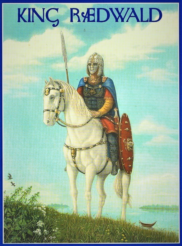
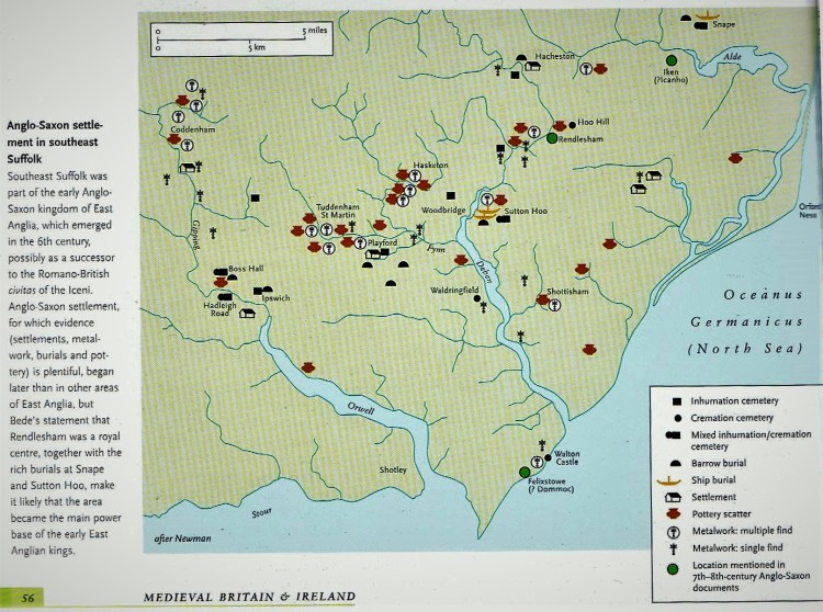
Some of these warrior kings traced their descent back to Woden, like the ‘Wuffings’ of East Anglia (see appendix one below). Early in the sixth century a group of settlers arrives in the Sandlings of Suffolk. They came from what is now Sweden and their leader’s name was Wehha. Whether they were simply better warriors than other bands or whether ovrercrowding forced them to become more aggressive and take the role of conquerors we cannot determine. What we do know is that Wehha’s family established the first kingdom of East Anglia. From their base at Rendlesham they ranged along the coasts and rivers forcing their will on all the settlements, demanding allegiance and payment of tribute. Within fifty years the Wuffings had brought most of East Anglia under their sway and the kingdom reached its zenith during the reign of Raedwald (c. 599-625), about whom I have written extensively in other recent articles published on my site.
Back in the west, meantime, Ceawlin had clearly become an outstanding warrior. He and his brother smetimes fought side by side, at other times went on separate campaigns. In 568, the Anglo-Saxon Chronicle tells us, ‘Ceawlin and Cutha fought against Aethelbert and drove him in flight into Kent’. Aethelbert was a powerful king, so this was no mean achievement. The quarrel had no doubt sprung from a border incident. Three years later, in 571, we hear of Cutha again in action, defeating the Britons at Biedcanford and capturing four towns: Limbury, Aylesbury, Bensington and Eynsham. This is an interesting campaign, since it looks as if he gathered a force (of Wuffing warriors?) in East Anglia and then drove west through Bedford and Aylesbury, reaching the Thames at Benson just north of Wallingford, and then travelling along the river to Eynsham, a Bronze Age settlement which grew up near the historically important ford of Swinford on the River Thames flood plain. Here he was on the edge of British-held territory, and the opposition would have no doubt been too strong for him to continue. The Chronicle also tells us that he died in this year: Perhaps he had been wounded by British swords, or the Thames Valley marshes proved even deadlier. But as one warrior fell and was laid ceremoniously to rest, there were, it seemed, as many as a dozen others ready to take his place. They often bore the same name or names remarkably similar to their immediate forbears, as the following entry for 577 in the Anglo-Saxon Chronicle:
In this year Cuthwine and Ceawlin fought against the Britons and killed three kings; Conmail, Condidan and Farinmail, at the place which is called Dyrham: and they captured three of their cities, Gloucester, Cirencester and Bath.
So, four years after Cutha’s great campaign, which nearly cut right across from east to west, an even more significant victory was achieved. Doubtless the Anglo-Saxons had by this time sailed around the coasts and gained a better idea of the strengths and weaknesses of the British positions. If Cuthwine’s thrust could have been sustained it would have struck at almost precisely the same point that Ceawlin reached. During the previous twenty years, as King of Wessex he had gradually been pushing back the north-west borders of his kingdom. Under normal conditions, the three kings of Bath, Cirencester and Gloucester would have been fighting each other, disputing some border territory, but they had held their strategic and tactical conferences. Although these essentially Roman towns were still populated, no longer possessed the political and economic importance they enjoyed under Rome. By a stroke of good fortune, Ceawlin’s invasion route led right through the centre of their territories so there could be no question of one of them fighting for his life while another stood idly by pondering when or where to intervene, if at all. A look at the map below shows that Ceawlin was planning to slip through the middle of their strongholds and break through on to the flood plains of the Severn Estuary at Berkeley. But the movements of his large army would doubtless have been faithfully reported by scouts and spies, and even though he had slipped past Bath there must been a huge force waiting to confront him elsewhere. As it happened, it was at Dyrham, but it was in a badly-chosen position. Nevertheless, even Ceawlin must have drawn breath when he came to Dyrham and wondered who would be standing victor on that field by nightfall.
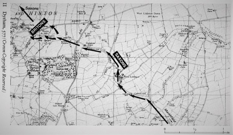
Another look at the map suggests that Ceawlin had brought his army through West Littleton. He may have thought that his three principal opponents were mainly intent upon guarding their own cities but, as it proved, they had concentrated their forces at the point he was almost certain to try to pass, Hinton Hill. Needless to say there have been a host of other theories about approach routes he might have chosen but they all lead to Hinton Hill. That this decisive battle took place near the modern village of Dyrham, seven miles north of Bath, is beyond doubt, and the precise location of Hinton Hill has been agreed on by many historians, one mile to the north of Dyrham (originally ‘Deorham’). This is the site of an Iron Age hill-fort, identified as ‘Dyrham Camp’. However, this name is of late-nineteenth-century origin, and in earlier centuries it was known as ‘Barhill’ an ‘Burrill’. It would therefore be wrong to accept uncritically that the fighting took place at the hill-fort, although this remains a possibility. A Saxon presence astride the commanding six-hundred-foot escarpment at Hinton was a challenge which the Britons could not ignore, and the forces of the three towns combined under their kings for a concerted attack upon the army of Cuthwine and Ceawlin. The battle may have taken the form of an attack by either side upon the fort on Hinton Hill but it could equally, and perhaps more probably, have been fought on the banks of the tributary of the River Boyd which flows below the south-west face of the escarpment.
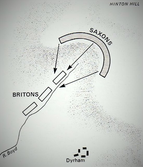
The Battle went decisively in favour of the Saxons, for all three British kings perished, suggesting that the Britons ended the battle surrounded and unable to escape. A Saxon attack launched at dawn from the escarpment, with the advantage and impetus of a downhill charge, may have swept through the British position before they could form to receive it. It looks as if Ceawlin’s warriors were first confronted about three hundred yards ahead of the camp position. The Britons would have had bows, but these were not as formidable as they were later to become. Such armour as they had was light, on the Roman model, but it is unlikely that many would have possessed it. The Saxon rank and file had no armour at all, but their leaders usually had a chain-mail shirt and an iron framework helmet. They had spears, bows and shields. The spears – on both sides – were simple seven-foot shafts with iron heads, which could be used for thrusting or thrown like a javelin. At this time, a spear was considered to be a more flexible and reliable weapon than a bow. After the first exchanges of spears and arrows at Dyrham it was undoubtedly close-quarter combat. Apart from these few facts about the place, the result and the names of the three kings, nothing else is known about the course of the battle, and, in the absence of any written contemporary accounts, the secondary accounts differ as to who was attacking and who defending, and from where. The Saxons seem to have possessed greater numbers, greater than the Britons had anticipated. The important outcome was that Ceawlin succeeded in breaking through to the Severn. He captured Gloucester, Cirencester and Bath with ease, for most of the usual defender of these towns were lying dead on the slopes of Hinton Hill. He had split the ‘Waelisch’ into those in the West, Cornwall and Brittany, and those in Wales and north-west Britain. But there were plenty of battles and skirmishes to follow. Seven years after Dyrham, the Anglo-Saxon Chronicle records:
584: In this year Ceawlin and Cutha fought against the Britons at the place which is called Ferthanleag and Cutha was killed there, and Ceawlin captured many villages and countless spoils and in his anger returned to his own land.
Ferthanleag was probably Fringford, a village four and a half miles north of Bicester (today’s Oxfordshire). In 593, a last significant entry in the Anglo-Saxon Chronicle tells us that Ceawlin ‘perished’, probably with sword-in-hand, and Aethelfrith succeeded to the Kingdom of Wessex. Four years later, we hear that the new king continually fought and contended against the English or the Britons or the Picts or the Scots.
The ‘Age of the Saints’ & The Consolidation of Christianity:

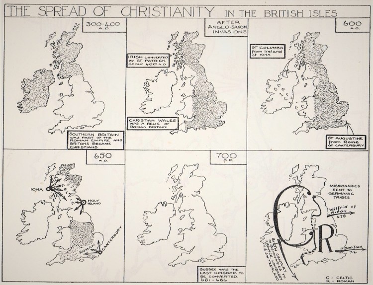
Up to the time of their defeat at Dyrham in the mid-sixth century, the Britons’ missionaries converted the pagans of the more remote areas of western Britain and then converted Ireland and those parts northern Britain that the Romans had never reached. This brought the British Isles into what is sometimes referred to as ‘the Age of the Saints’. The process of conversion had begun, in fact, shortly before the Roman withdrawal, in northern Britain. In 397 St Ninian introduced Christianity to Galloway, outside the province itself, where he built a small stone church covered with white plaster at Whithorn. Remains of a building corresponding to this description have been uncovered in excavations. The remains are now housed in the thirteenth-century Premonstratension priory and include the Latinus Stone of 450, the earliest record of Christianity in Scotland. Three miles away on the coast can be seen St Ninian’s cave (above), which he used as an oratory. Inside the cave and on the rocks outside are carved votive crosses which are said to date from the eighth century. The complete conversion of Scotand to Christianity was carried out by Irish missionaries in the tenth century. Christians had first arrived in Ireland to escape the barbarian invasions on the continent. By 431 there were enough Christian converts for Rome to appoint a bishop for them. When the Angles, Saxons and Jutes settled in Britain, they continued to worship their own pagan gods, and they attacked the Christian religion which had continued to spread among the Britons, especially in Wales and Cornwall, where Christianity survived and thrived. However, the Britons made no attept to convert the ‘invaders’, preferring to send missionaries like Patrick to Ireland.
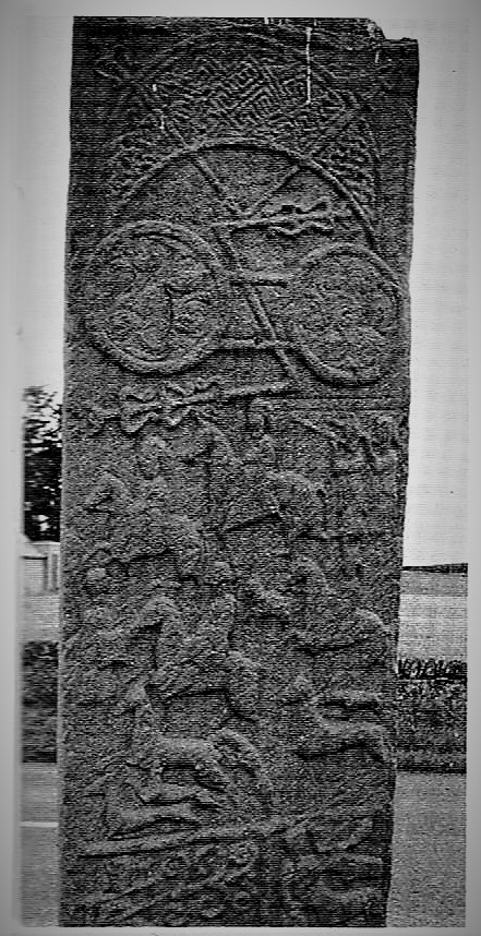
Patrick, a native of Cambria who had spent some time in Ireland after being captured as a slave by pirates, returned there on his great mission from 432 to 461. Not only did he teach the Christian message, but he also spread Roman civilzation there. Patrick’s conversion of the Irish kings had practical benefits for the success of his mission: on a wider scale, it led to a happy and fertile fusion between Christianity and Celtic traditions that flowered for hundreds of years in the manuscripts, metalwork, sculpture and architecture of Ireland. The country became a great centre of learning and art. In preaching the Trinity, he found the Irish people already prepared by the Celtic veneration of the number three. He died in 461, but though he had introduced episcopal administration of the Church, the path the Celtic Church followed in Ireland was heavily influenced by eastern monasticism, brought to Ireland via Tours. It integrated better with native Irish customs than did the Roman rites. Irish monks became famed for their missionary zeal. What these early monks would do to find freedom to pray and contemplate is shown at its most extreme at the island of Skellig Michael, eight miles off the south-west Irish coast. There the ‘beehive’ cells of the monastery testify to the heroic disregard of bodily sufferings or rather the inviting of them as the monks strove to dispossess their inner natures of personal desires and thoughts in their surrender to divine contemplations. A great number of early monastic sites survive, often in more kindly surroundings. In such monasteries, much of permanent value from the ancient world was preserved for Western civilization. The saints and monks loved learning and in their desire for knowledge and its transcendence, they changed themselves, returning to the European mainland with the gifts they had received, founding monasteries there and becoming bishops.
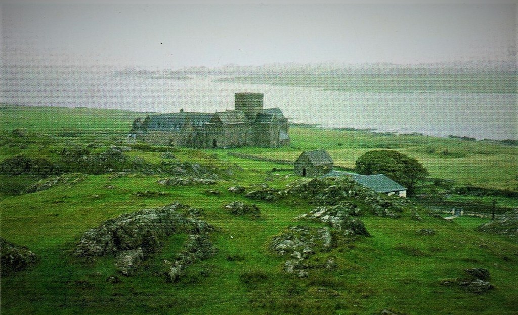
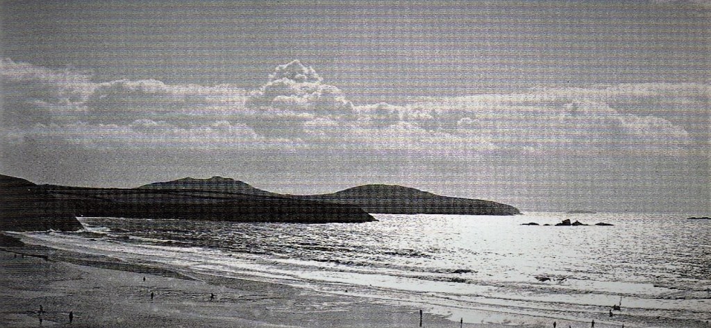
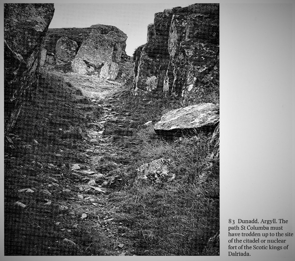
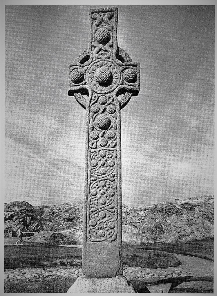
Some of the travelling saints journeyed unwillingly. Columba (or Columcille) left Ireland in 563 at the age of forty-one, as a penance for unwittingly causing a war by copying out a Vulgate belonging to his old tutor. He had already established two noted monasteries at Derry and Durrow. Accompanied by twelve ‘disciples’, he set sail northwards and came to the island of Iona in the Hebrides. On landing, he climbed a hill to make sure he could not see Ireland so that he would not ‘be tempted by the shadow of his homeland on the water’. He then founded a monastery from which for thirty-four years he worked for the conversion of Scotland. Known earlier as the island of the Druids, Iona possesses sacred wells which were probably the scenes of earlier pagan rites, as well as Sithean Mor, ‘the great mound of the fairies’ or rather ‘the Hill of Angels’ because there is a record stating that Columba was praying there when he was visited by a band of angels. But there are few remains of Columba’s own time, except his cell and his stone bed. The cathedral is largely of the sixteenth century, incorporating a twelfth-century nunnery and an ancient oratory which held the saint’s shrine. From Iona, Columba travelled across Scotland, meeting St Mungo who was buy at work converting the people of Strathclyde, visiting Dunadd, the seat of the Scotic kings of Dalriada, and founding Christian settlements on the mainland. He died on Iona in 597, the same year that the Augustine brought Roman Christianity to the Jutes of Kent.
But if Christianity was not before the end of the Roman province, it was already becoming so by the end of the fifth century, by which time it was sufficiently vigorous to reach beyond the Roman frontiers. Patrick is only the most famous of several missionaries to Ireland and northern Britain who had a profound effect on the political as well as the religious landscape. Within a few generations, the Irish were bringing monastic Christianity back to Britain and the Continent. The most famous of the Irish foundations was undoubtedly Columba’s monastery on Iona, and during the sixth and seventh centuries Iona emerged as the greatest Christian centre in northern Britain, with strong political links that extended its influence into Bernicia through the monastery of Lindisfarne, the great Northumbrian monastery, was founded by a monk from Iona, Aidan, ‘the candle of the north’. This influence of Iona spread far, not just across Scotland, but also throughout the North of England. Monks from Iona converted the inhabitants of both the Highlands and Lowlands of Scotland – the Picts and the Scots – and later, the Angles of Northumbria. Only in this one of the Anglo-Saxon kingdoms is there significant evidence for cultural integration between incomers and natives. Here the level of Anglian settlement was lighter and a high degree of continuity can be seen in the landscape and social institutions of the kingdoms of Bernicia and Deira.
By contrast, there was a much greater degree of social integration among the different Celtic peoples of western Britain and Ireland. For a time, Dál Riata in western Britain spanned the North Channel; elsewhere, ogham inscriptions are a permanent record of a more ephemeral Irish presence. The Irish Sea served as the main conduit by which the Britons and Gaels maintained contact with the continental Christian heirs to Rome. Finds of pottery and glass provide evidence for a vigorous trade with the Mediterranean and western Gaul, in which wine was was probably the most important import. At the time, wine was the most prestigious alcoholic drink, but perhaps more importantly it was essential for the conduct of the Christian mass.
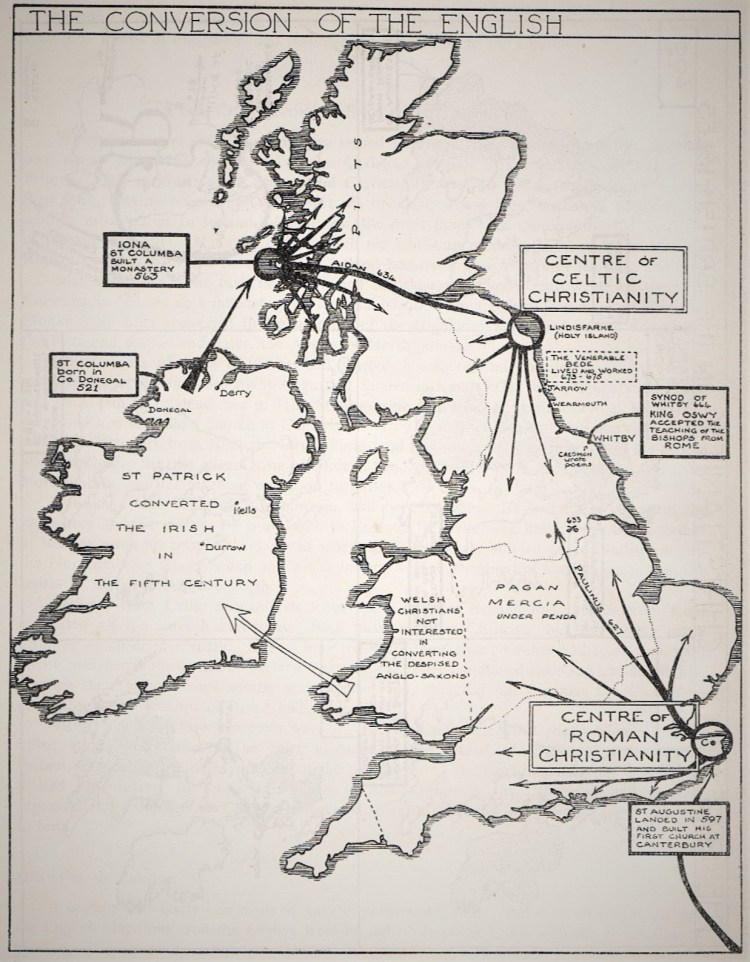
Thirty years after St Columba had started his sacred mission in Iona, a group of missionaries from Rome, led by Augustine, landed in Kent (597). ‘Pope’ Gregory had sent them and they had some early success with the conversion and baptism of King Aethelbert of Kent, who was also recognised as the ‘Bretwalda’ or senior ruler in the Heptarchy, and King Raedwald of East Anglia, who was therefore ‘subject’ to Aethelbert. When the latter ordered the East Anglian king to be baptised, Raedwald complied. Officially, therefore, according to the Roman tradition, East Anglia became ‘Christian’ during the reign of Raedwald, probably circa 603. But his ‘conversion’ did not go very deep, and his queen’s strong adherence to the old faith ensured that her husband would only regard the Christian God as a recruit to the company of Woden, Thunor and Frig. But the two religions were were now locked in a combat which would prove fatal for one or the other. Aethelbert allowed Augustine to build a church at Canterbury, but his successor reverted to paganism, and Augustine was forced to abandon his mission.
In Augustine’s absence, the Celtic missionaries from the north continued the work of coverting the English kingdoms, beginning with East Anglia, into the seventh century. The Celtic churches, monasteries and missions had lost touch with Rome over the previous two hundred years. They conducted their services differently and though their bishops organised their churches efficiently, the Bishops of Rome wanted a uniform and centralised church under their control. Gregory was the first of them to use the title ‘Pope’ and to be widely recognised as such, but this was by no means universal and the Irish bishops were keen to maintain their independence from Rome. This led to may disputes between the Irish and Roman missionaries later in the century (see the map above). The conversion of the Angles, Jutes and Saxons was enabled by the growing stability of their nascent kingdoms in the late sixth and early seventh centuries and, in turn, the growing influence on the lives of the people, making them less warlike and more willing to accept just laws and preparing the way for them to become more united in their allegiances to both church and state.
The Formation of the Cultures & Kingdoms of the Isles:
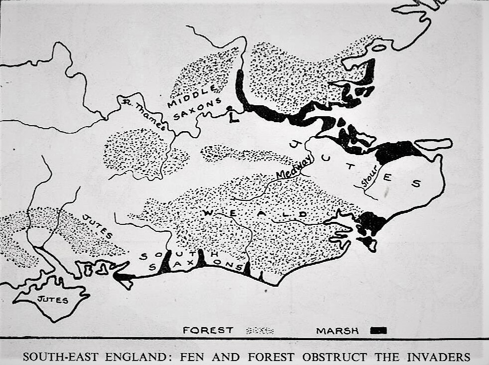
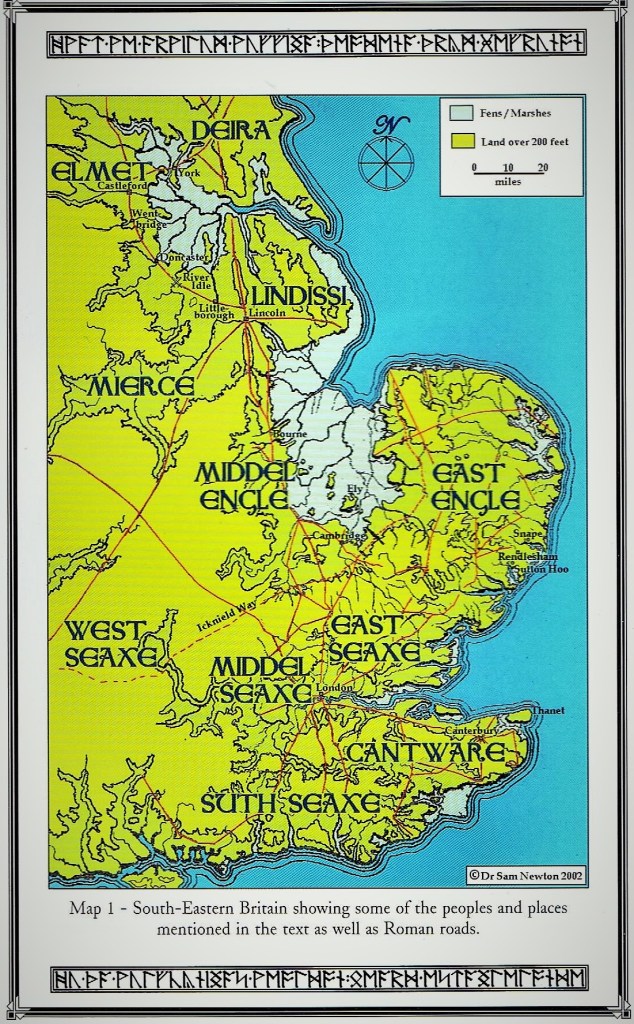
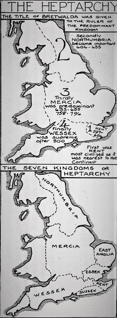
The maps above, of the south-east and below, of East Anglia, show how natural obstacles, such as marsh or forest, helped to keep separate the groups of settlers. The Jutes’ bridgehead in Kent was protected to the north by the marshes along the estuary of the Thames, while to the south spread the impassable forest of the Weald. The South Saxons were confined to the coastal plain between the Weald and the Channel coast. The Middle Saxons settled on the patches of well-drained gravels along the lower Thames, and were protected to the north by the thick forests covering heavy, uncultivable clays (e.g. Epping Forest). As the settlements became established, the political focus of the settlers became centred less on defeating the Britons in the North and West and more on the dynastic struggles of the kingdoms of the Heptarchy; Wessex, Mercia, Northumbria, East Anglia, Essex, Sussex and Kent. At the beginning of the seventh century Northumbria was divided into the two separate Anglian kingdoms of Bernecia and Deira, the former centred on Bamburgh, the latter upon the Yorkshire Wolds. The transformation of these isolated English settlements into the most powerful kingdom in northern Britain was begun by Aethelfrith, the last pagan king of Bernicia, who reigned c. 593 to 616. The expansion of Bernecia was achieved through Aethelfrith’s considerable military skill, and his first opponents were the Scots of Dalriada (Argyll). Under their king, Aeden Mac Gabran, the Scots pushed southwards into Bernecia but were defeated by Aethefrith at Degastan in 603. Aedan’s army was all but wiped out and this decisive victory secured Northumbria from attack from the north.
Aethelfrith next turned south-west, moving against the Britons of Powys. Whether he advanced southwards from Carlisle or westwards through the Kingdom of Elmet it must have been a difficult march, but such was his speed that the Britons were taken by surprise and forced to give battle before their full strength had been mustered. Only the followers of Selyf ap Cynan of Powys, supported by men from the province of Gwynedd, took the field against Aethelfrith at the Battle of Chester in c. 615. Nearly 1,200 monks from Bangor-on-Dee, from an abbey going back to the foundations of Christianity in Britain, also took to the battlefield, whether to offer prayer in support or to fight alongside the Britons is not entirely clear. Whatever their purpose, Aethelfith’s pagan troops were not troubled by any possible distinction between warriors and non-combatants and they slaughtered the monks as a preliminary to the main battle. The Britons were comletely defeated, and both their leaders, Selyf ap Cynan and Cadwal of Rhos were killed. It is difficult to say whether Aethelfrith launched the campaign the campaign as a raid or as a deliberate attempt to drive a final wedge between the Britons of Wales and those in Cumbria and Strathclyde, but if the latter was the case it is strange that the battle was not followed by Northumbrian settlement in the west.
Nevertheless, this final battle between the Britons and the Saxons at Chester in c. 615 was significant in completing the separation of the Britons into four regions; West Wales (including Cornwall), North Wales (Wales), Cumbria and Strathclyde. These regions, with their many moors and mountains, were not attractive to the largely ‘lowland-bred’ Anglo-Saxons.The absence of any significant immediate or lasting result from the battle may perhaps be explained by the death of Aethelfrith one year later at the hands of Raedwald of East Anglia at the battle of the River Idle the following year, in which Britons are thought to have fought to avenge their losses at Chester. The Welsh Trioedd Ynys Prydein (‘Triads of the of the Island of Britain’), dating from the thirteenth century, refer indirectly to the Battle of the River Idle. Triads ten and thirty-two describe the “Three Chieftains of Deira and Bernicia” who had performed “three fortunate slayings”. One of these chieftains was ‘Sgafnell the son of Dissyndawd’, who is remembered for his “fortunate slaying” of ‘Edelfled’ (Aethelfrith). It has been argued that these references imply that British warriors with grievances against Aethelfrith fought as Raewald’s allies at the Battle. The new political order of the Heptarchy was later identified by the Anglo-Saxon chroniclers as providing the origins of the English nation.
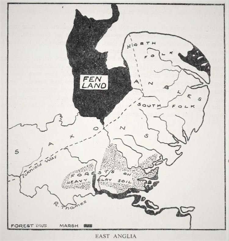
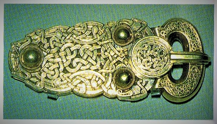
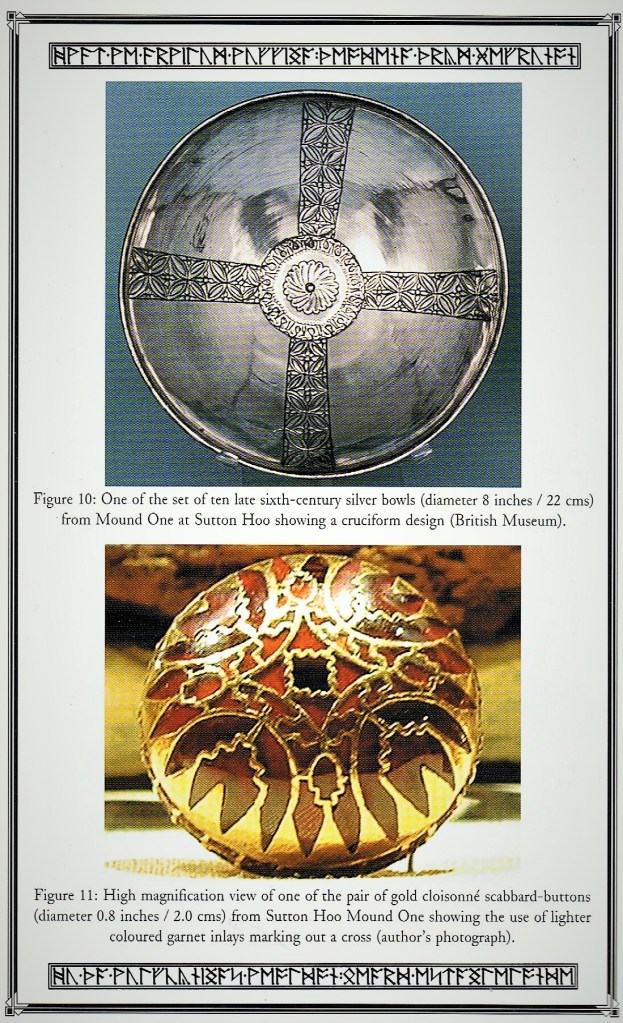
The Angles who settled in the land between the Wash and the Thames estuary were confined by the marshes of Fenland to the west and the dense forests on heavy clay soil to the south. In this compact area the kingdom of East Anglia developed, the estuary of the Yare and the Wensum dividing the North Folk (Norfolk) and the South Folk (Suffolk). In the north and in the Midlands the boundaries of settlement were not so clearly defined by geographical obstacles, and, with rulers who were always fighting each other and frontiers that were ill-defined and always changing. Although we continue to refer to a ‘Heptarchy’, as shown with their ninth-century boundaries on the map below, in fact, the smaller kingdoms were independent only for short periods, and there were never seven kingdoms at any one time. It is natural that, during the early struggles between the kingdoms, one ruler should try to make himself supreme over the rest. He was recognised as ‘Bretwalda’, meaning ‘overlord’ or ‘high king’. In the period to 616, the title passed from Aethelbert of Kent to Raedwald of East Anglia and on to Edwin of Northumbria. When Raedwald’s ship burial at Sutton Hoo was uncovered in 1939, many objects of Celtic and British design were among the treasures discovered. In addition, a mixture of pagan and Christian symobols was found on these goods.
At the local level, the Anglo-Saxons disliked living in towns and their arrival coincided with a drastic decline in urban life and a reorganisation of the landscape, partly as a result of large-scale population movement. London was probably the only place where urban life continued on any significant scale. Many Roman towns were ‘robbed out’ and left abandoned, like Silchester, where Arthur was said to have been made ‘Bretwalda’ of the Britons. The newcomers settled in villages at some distance from the Roman roads, the suffixes ‘-ham’ or ‘-ton’ in a place-names denoting the site of a Saxon village. Wherever they settled they farmed the land. Ruled by kings, their most important landlords were called Thegns, holding land granted by the king and having certain rights over the ‘free men’, small-holding farmers.
The ‘Thegns’ presided over the ‘moots’, where matters of common interest were discussed, and a rough sort of justice was carried out. Freemen could be summoned by the king to serve in an army called ‘the Fyrd’. There were also slaves, including some of the Britons whose lives had been spared during the raids. Aerial photography has also revealed the survival of Celtic field patterns into the Saxon period, suggesting that many British farmers stayed on their lands after their warlords had moved westward.
There can be little doubt that the long period of conflict that followed the Roman withdrawal from Britain heightened ethnic tensions and refined the competing identities. A new political landscape, consisting of small kingdoms that owed little to the Roman provincial structures, emerged, largely on ethnic-linguistic lines. In many respects both Celtic and Anglo-Saxon social organisation was similar, but there were profound linguistic and religious differences. By the time of the collapse of the Roman province, Christianity had a significant number of adherents in Britain, while the Saxon homelands remained resolutely pagan. The Anglo-Saxon population in Britain remained pagan until well into the seventh century, regardless of dynastic decisions. Following the English settlement, there were three broad cultural ‘zones’: Britain was divided between the ‘English-speaking’ east and the ‘Celtic-speaking’ north and west where the Brythonic language, ancestral to Welsh, and Pictish languages persisted, while in Ireland and in enclaves in the western highlands and islands, different Gaelic languages were spoken. These zones to some extent reinforced cultural distinctions establihed in the Roman period, and the most Romanised part of Britannia, where there had been towns and villas, broadly corresponds to the area occupied by the early Anglo-Saxon kingdoms. These zones, while not static, can be mapped through early medieval place-names.
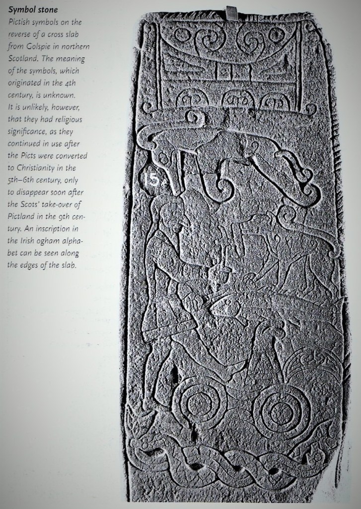
Within the ‘British zone’, there is a far greater degree of continuity in the settlement record, particularly regarding centres of power. Edinburgh Castle stands on a hill that was first occupied in the Bronze Age and typifies a preference for prominent, defended strongholds. Some Dark Age hillforts, like South Cadbury, were reused Iron Age hill-forts; others, like Dumbarton or Bamburgh, were newly built on strategic landmarks. In instances where the local setting can be reconstructed, the prehistoric ritual landscape seems to have played a part in the selection of the site. Despite this cultural continuity, British kingdoms started to appear at the same time as the earliest Anglo-Saxon ones. In Ireland, too, this was an era of political reorganisation. Large provincial divisions came to overlie a network of smaller kingdoms, whose ruling élites began to appear in the sixth century. The preferred settlements of the Irish nobility were either elaborately defended homesteads (ring-forts) or artificial islands (crannogs). Links to the past remained strong, and some of the pre-eminent prehistoric religious complex, notably Tara and Emain Macha, which were believed to have been the seats of mythological kings, as a result retained a great symbolic significance. Different communities of religious belief are apparent from the range of material culture left behind. From an archaeological perspective, the most pronounced differences relate to funerary practice. The British and Irish erected inscribed memorial stones, but their burials were neither clothed nor furnished. The British inscriptions, written in Latin, are unmistakenly Christian. The Irish examples, written in Gaelic using an indigenous ogham alphabet, are more ambiguous, but may be Christian. The so-called ‘symbol stones’ of Pictland represent a related tradition, though employing a pictorial rather than an alphabetic system.
Here, the contrast with the Anglo-Saxon world is profound. Here there are no inscribed memorial stones, and burial practice followed the traditions of their continental homelands. The scale of Anglo-Saxon settlement can be gauged from the widespread distribution of fifth-century Anglo-Saxon cemeteries. The earliest hint of Anglo-Saxon presence is seen in graves from late Roman cemetaries that contain belt-fittings and other metalwork regarded as stylistically Germanic. During the fifth and sixth centuries a wide range of burial rites developed, which included the elaborate use of clothing and equipment to signal social position and to mark out special individuals at burial or cremation. Important graves might be further dignified by the construction of a mound or barrow. Traditionally, such burials were have been taken as reflecting pagan religious belief, but arguably they were to reinforce the social order or to express political aspiration. The patterns of burial rites within individual Anglo-Saxon cemeteries tends to be the same, but there is a huge range of minute ritual variation between cemeteries.This can be interpreted as the means by which neighbouring settlements sought to strengthen group identity. The artefacts recovered from cemetery excavations reveal the technical accomplishments and rich material culture of the early English peoples, but they also offer insghts into the beliefs and values of a society dominated by its warrior aristocracy. The prominence of weaponry in male graves leaves little doubt as to the role of arms and warfare in defining social status. Clothing, jewellery and domestic objects formed the vocabulary of the female burial rite.
Zones of Transition & Questions of Identity:
The precise nature of the transition from Roman Britain to an island divided between ‘zones’ of Anglo-Saxons and Post-Roman Celts is not as clear as we might think. At first sight, the traditional picture of a violent replacement of one people by another seems to be borne out. But closer examination raises a number of questions, which may be resolved by work still in progress. A lot more of Roman Britain could have survived, even in the east, than used to be suspected. And there is no reason why the same course of events in one region should have been repeated across others. In some areas of Norfolk, for example, there may have been wholesale replacement of the original population by another, while elsewhere settlers may have been a subordinate minority, there on sufferance. Or in other areas, the newcomers may have come to an agreement with the natives. In Northumbria, there was a new ruling élite, but the population seem to have remained largely British. When, in later centuries the peoples of south and eastern Britain called themselves Angles or Saxons, we have to allow for the possibility that this may not have reflected a straightforward ethnic fact. Writing in the eighth century, Bede was sure of his own ‘Englishness’ and unenthusiastic about the Britons. Yet there is little evidence for mass immigration of Anglo-Saxons north of York. Bede was writing at Jarrow in Northumbria, where the ruling dynasty, and their immediate retinue, may well have been Anglian. But the rest of the population was of British descent, who, however, identified with their rulers, either willingly or because it was prudent to do so. The sense of belonging to a particular area, East Anglia or Sussex, Northumbria or Kent, would have increased as time went by. But many areas we now think of as ‘English’, like Somerset (‘England’s pastures green’ according to Blake’s ‘misnoma’) and the West Midlands, were not even nominally Anglo-Saxon until long after the first migrations.

Sources:
William Anderson & Clive Hicks (1983), Holy Places of the British Isles: A guide to the legendary and sacred sites. London: Ebury Press.
Sam Newton (2003), The Reckoning of King Raedwald. Colchester: Red Bird Press.
Philip Warner (1976), Famous Battles of the Midlands. Glasgow: Fontana.
Stephen Driscoll (et. al.) (2001), The Penguin Atlas of British & Irish History. London: Penguin Books.
Derek Wilson (1977), A Short History of Suffolk. London: Batsford.
Catherine Hills (1986), Blood of the British: From Ice Age to Norman Conquest. London: Guild Publishing.
David Smurthwaite (1984), The Ordnance Survey Complete Guide to the Battlefields of Britain. Exeter: Webb & Bower.
Appendix One: Sam Newton’s Genealogy of the ‘Wuffings’.

Appendix Two: Matthew Paris’s Map of the Anglo-Saxon Heptarchy.

No maps of Britain have survived from the period of the fifth to the eleventh centuries, a crucial time in the nation’s development which saw the collapse of the Roman province of Britannia, waves of invasions by Germanic barbarians and, ultimately, the emergence of unitary kingdoms in England and Scotland. Yet cartographic representations of this formative period do survive from a little later, for example in the form of a schematic map showing the Anglo-Saxon kingdoms by Matthew Paris, a thirteenth-century Benedictine based at the Abbey of St Albans. Paris gives then numbers, establishing the primacy of Kent as the earliest kingdom, and Essex as the most recent. Although elsewhere he repeats the traditional mythology that all these kingdoms emerged within a single generation, Paris confesses that with the passing of time it was difficult, in his time, to elucidate the dimensions, frontiers and even the chronological ordering of these kingdoms. His scheme was an oversimplication. The Angles, Saxons and Jutes who crossed the North Sea in the decades following the collapse of Roman authority did not establish neat territory kingdoms. As the invasders pushed further north and westwards, the war-bands and the authority of local chieftains coalesced into larger units, which became the seven kingdoms. But even in the eighth century, their were less powerful territories, particularly in the West Midlands, which remained independent, though usually shown in more recent maps as part of Mercia.
